
At 2,932 meters, Mount Hakuba is the highest peak of the Ushiro-Tateyama range and the 26th-tallest mountain in Japan — a genuine alpine giant that happens to be one of the most approachable big-mountain experiences in the Northern Japan Alps. It is also a mountain with two names, and sorting that out is the first step to planning the trip.
The White Horse of the Northern Alps
The official name on government maps is Shirouma-dake (しろうまだけ). The kanji, 白馬岳, can also be read Hakuba-dake — and that reading took over after the railway station at the mountain’s foot was named “Hakuba” in 1906, then rode the ski resort’s fame to global recognition. Same mountain, same kanji. The name itself comes from a spring snow patch on the mountainside shaped like a horse pulling a plow — shirokaki-uma — which farming villages once used as the signal to begin planting. Over time the characters settled into 白馬, “white horse.”
This guide covers the classic route: the Sarukura trailhead, the walk up the Daisekkei snow valley, the summit, and the mountain huts — plus how to get there from Tokyo, when to go, and what the mountain demands of you. It is a serious alpine hike, but it is also one of the great two-day trips in Japanese mountaineering.
Table of Contents
Quick Facts
| Elevation | 2,932 m (26th-tallest in Japan) |
| Location | Nagano / Toyama border, Northern Japan Alps, Chubu-Sangaku National Park |
| Notable | One of Japan’s 100 Famous Mountains; highest peak of the Ushiro-Tateyama range |
| Classic route | Sarukura trailhead → Daisekkei snow valley → Hakuba Sanso → summit |
| Distance / gain | About 10.9 km round trip, ~1,220 m of elevation gain |
| Typical time | About 6 hours Sarukura to summit; realistically a 2-day trip |
| Difficulty | Moderate to hard — an alpine route, not a day-hike stroll |
| Best season | July to August for the classic trip; September to early October for quieter, cooler hiking |
| Access | Ltd. Express Azusa Shinjuku → Hakuba (~3h40m, twice daily), then seasonal bus to Sarukura (~30 min) |
Getting There from Tokyo
Hakuba is well connected for a mountain this serious. Three main options from Tokyo:
- Ltd. Express Azusa (simplest): direct from Shinjuku to Hakuba in about 3 hours 40 minutes, running twice daily. Check the current timetable before you travel — two trains a day means missing one costs you hours.
- Shinkansen + bus: Tokyo to Nagano by Shinkansen (about 1.5 hours), then bus from Nagano to Hakuba (about 1–1.5 hours). Through fares run roughly ¥10,000–11,500 one way, but verify current prices on the JR East site.
- Overnight highway bus: from Shinjuku or Tokyo Station to Hakuba in about 5.5–6 hours, typically around ¥3,200–3,900 — the budget option, and you arrive at dawn ready to move.
From Hakuba village, the Sarukura trailhead (~1,250 m) is about 30 minutes by seasonal Alpico bus or taxi. The bus timetable varies by season — confirm the current schedule on the Alpico site before you go, since missing the last bus back strands you at the trailhead.
The Route: Sarukura, the Daisekkei, and the Summit
The classic Mount Hakuba hike starts at Sarukura, where the Sarukura-so lodge marks the trailhead. From here the route climbs to the mouth of the Daisekkei — and this is where the mountain shows its character.
The Daisekkei: Japan’s great snow valley
The Daisekkei (白馬大雪渓) is one of Japan’s few year-round snowfields: about 3.5 kilometers long with roughly 600 meters of elevation gain, the largest snow valley in the country. Snow persists here even in midsummer, and you will be walking on it — this is a snow-valley ascent, not a summer trail that happens to cross a patch of snow.
Two things matter here. First, crampons are strongly recommended even in July and August. The snow is real, it is steep in places, and a slip has consequences. Light 4-point crampons can be rented at Sarukura-so, Hakuba Sanso, and the Tsugaike hut for ¥1,500 (with ¥500 refunded when you return them to any of the three) — there is no excuse for going without. Second, rockfall is the signature hazard. The valley walls shed stones, especially as the day warms. Keep moving through the exposed sections, don’t linger under the cliffs, and consider a helmet.
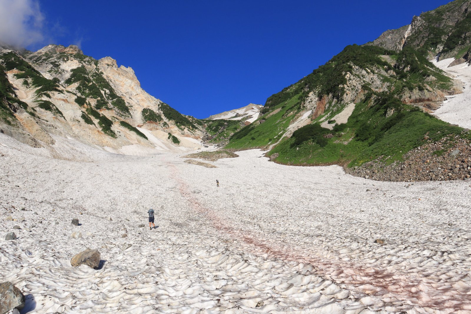
Photo: Alpsdake, Wikimedia Commons, CC BY-SA 4.0 — The Shirouma Daisekkei snow valley, Nagano
Above the snow: alpine meadows and the summit ridge
Above the snowfield, the route opens into alpine meadows — this is flower-mountain country, and mid-July to mid-August is the celebrated season for it. The trail then climbs to the Hakuba Sanso area at 2,832 meters, just below the summit, and from there it is a final push to the 2,932-meter top.
All told, Sarukura to summit takes most hikers about 6 hours. The honest shape of this trip is two days: climb to the hut area on day one, summit (at sunrise if you’re keen), and descend on day two. Attempting it as a single day from Sarukura is possible for very fit hikers with an alpine start, but it leaves no margin — and this mountain punishes haste.
Mountain Huts: Book Ahead
Hakuba Sanso (白馬山荘), at 2,832 meters just below the summit, is the key hut: capacity around 800, operating since 1906, and billed as Japan’s largest mountain hut. The 2026 season ran April 25 to October 12, with full summer services from late June — always verify the current year’s dates before planning.
Reservations are web-only and required, with a ¥3,000-per-person-per-night deposit (non-refundable, counted toward your bill). Dormitory pricing per adult runs roughly ¥12,000 without meals to ¥16,000 with two meals; private rooms cost more. Walk-ins without a stay pay a surcharge. There is also the Hakuba-dake Chojo Shukusha near the summit and the Sarukura-so lodge at the trailhead. A medical clinic operates inside Hakuba Sanso in mid-summer — and its caseload is dominated by altitude sickness, which tells you everything about pacing yourself on this mountain.
The Hakuba Sanzan Traverse
For hikers with 2–4 days, the classic extension is the Hakuba Sanzan traverse: three peaks in one expedition — Shirouma-dake (2,932 m), Shakushi-dake (2,812 m), and Hakuba-yarigatake (2,903 m). The usual shape is up the Daisekkei, along the ridge tagging all three summits, and down via the Yari Onsen — a natural hot spring at about 2,100 meters that makes a magnificent end to the trip. Note that Hakuba-yarigatake is a separate peak from Shirouma-dake despite the similar name; don’t confuse the two when route-planning.
When to Go
July to August is the main season: huts fully open, the Daisekkei at its most walkable, alpine flowers at their peak from mid-July to mid-August. It is also the busiest — book huts well ahead.
September to early October is the connoisseur’s season: cooler, quieter, and excellent underfoot as long as the huts are still open. Autumn foliage hits the high-alpine zones from late September to early October. But the season ends decisively — the first snow and ice were observed on the upper mountain in late September 2026, and once the huts close (typically mid-October), the mountain reverts to full winter-mountaineering conditions.
How Hard Is It, Honestly?
This is a genuine alpine route, not an ambitious day hike. The 1,220 meters of gain, the snow-valley travel, the exposure near the top, and the altitude (nearly 3,000 m — altitude sickness is the clinic’s main business) put it firmly in the “fit, equipped, prepared” bracket. If your experience tops out at Takao or Mitake, build up through intermediate Northern Alps routes first.
That said, it is also one of the most rewarding step-up objectives in Japan: the logistics are straightforward, the huts are excellent, the Daisekkei is unforgettable, and the summit panorama across the Northern Alps is among the finest in the country.
Safety Notes
- Weather: at nearly 2,900 meters, conditions change fast. Carry rain gear and warm layers even in August.
- Rockfall in the Daisekkei: keep moving through exposed sections; a helmet is a reasonable precaution.
- Crampons: even in midsummer on the snow valley. Rent them at Sarukura-so if you don’t own a pair.
- Altitude: ascend steadily and hydrate — altitude sickness is the most common reason hikers visit the summit clinic.
- Thunderstorms: the standard Northern Alps summer pattern. Start early and aim to be off the exposed ridge by early afternoon.
- Bears: Asian black bears inhabit the Northern Alps, and 2025 was a record year nationally for sightings. Carry a bear bell, stay on the trail, and never leave food scraps — standard precautions, seriously observed.
What to Pack
- Crampons (light 4-point): non-negotiable for the Daisekkei, even in August. Rent at Sarukura-so for ¥1,500 if needed.
- Helmet: recommended for rockfall in the snow valley.
- Full rain gear and warm layers: alpine weather, even in midsummer.
- Sturdy boots: snow, rock, and long descents — trail runners won’t cut it here.
- 2+ liters of water and all food: carry everything; don’t count on resupply above the huts.
- Headlamp, map, first aid: the 2-day standard — and a charged phone with the hut’s number saved.
- Cash: hut payments, deposits, and the crampon rental are cash-friendly territory.
- Bear bell: clip it on from the trailhead.
Our Tips
- Book Hakuba Sanso the moment reservations open. Web-only, deposit required, and August weekends sell out. This is the single most common trip-ruiner.
- Rent the crampons even if the valley “looks fine.” Morning snow is hard and fast; the ¥1,500 rental is the cheapest safety purchase on the mountain.
- Time the Daisekkei for the morning. The snow is firmer, rockfall risk is lower before the afternoon melt, and you’ll reach the hut with daylight to spare.
- Don’t skip the flower season if you can choose. Mid-July to mid-August in the meadows above the snowfield is the reason this mountain is on the famous flower-mountain lists.
- Consider the Yari Onsen descent. If you’re doing the Sanzan traverse, ending at a natural hot spring at 2,100 meters beats retracing your steps.
Mount Hakuba FAQs
Is Mount Hakuba the same as Shirouma-dake?
Yes. Shirouma-dake is the official map name; Hakuba-dake is the alternate reading of the same kanji (白馬岳), popularized after the local railway station was named Hakuba in 1906. Don’t confuse it with nearby Hakuba-yarigatake, a separate peak.
Do I need crampons in summer?
Strongly recommended, yes — even in July and August. The Daisekkei is a genuine year-round snowfield, and light 4-point crampons can be rented at Sarukura-so, Hakuba Sanso, or the Tsugaike hut for ¥1,500 (¥500 refunded on return).
Can I do it as a day trip?
Very fit hikers manage Sarukura–summit–Sarukura in a long day, but the honest answer is no for most people: ~6 hours up, 1,220 m of gain, snow travel, and altitude. Plan two days with a hut night — it’s a better trip in every way.
When do the huts open and close?
Hakuba Sanso’s 2026 season was April 25 to October 12, with full summer services from late June. Dates shift yearly — verify the current season on the official hut site before booking transport.
How do I book Hakuba Sanso?
Reservations are web-only through the official site, with a ¥3,000-per-person-per-night deposit. Book as early as you can, especially for August weekends.
Is the Daisekkei dangerous?
It demands respect rather than fear. The main hazards are rockfall (keep moving, consider a helmet) and the snow itself (crampons, even in summer). Go in the morning when the snow is firm and rockfall risk is lowest.
The Bottom Line
Mount Hakuba is the Northern Alps at their most generous: a 2,932-meter summit with straightforward logistics, Japan’s greatest snow valley as the approach, excellent huts, and flower meadows above the snow. Treat the Daisekkei with respect, book the hut early, and give it two days.
