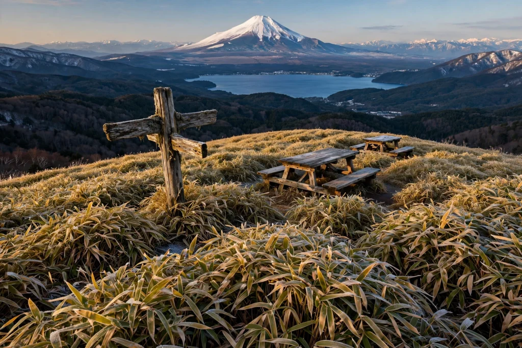
There is a small mountain on the western shore of Lake Motosu that most visitors to the Fuji Five Lakes drive straight past — and that is exactly why the Mount Ryugatake hike deserves your attention. At 1,485 metres, Ryugatake (竜ヶ岳) is no giant, yet from its broad, grassy summit the view of Mount Fuji is so perfectly composed that photographers plan entire New Year holidays around a single sunrise.
This guide is the most detailed English walkthrough of the Mount Ryugatake hike you will find anywhere. It covers all five trailheads, the step-by-step route, honest seasonal advice, and the practical details other guides skip — from which free parking lot has a usable toilet, to why the first bus from Kawaguchiko is useless for sunrise, to what 400 people on a small summit actually feels like on New Year’s Day.
Whether you are chasing Diamond Fuji in deep winter or a quiet autumn ridge walk with the whole of Lake Motosu below you, here is everything you need to plan it properly.
⛰️ Mount Ryugatake: Quick Summary
Everything from the guide below, condensed — plus a few things most guides skip.
📊 Hike Summary
Distance
~6.6 km round trip (Lake Motosu loop)
Elevation gain
~600 m (summit 1,485 m)
Time
~3.5–4 hrs at a comfortable pace
Difficulty
Moderate🚌 Getting There
By car it is about 2 hours from Tokyo via the Chuo Expressway to Kawaguchiko IC, then Route 139 west for about 25 minutes. By public transport, take a Fujikyuko bus from Kawaguchiko Station toward Lake Motosu.
- The first bus reaches the lake area around 10:07 am — fine for a relaxed day hike, but useless for sunrise or Diamond Fuji plans.
- Bilingual timetables are available at the tourist information desk inside Kawaguchiko Station.
- Parking is free: several lots sit along Route 139 and the lakeshore near the trailheads.
- On New Year’s Eve the lots fill by around 5 am — the car-camping crowd arrives the night before.
🧭 Choose Your Trail
Ishibutsu / Campsite Course
The classic ascent: steep forest switchbacks past moss-covered stone Buddhas to the covered observatory at 1,235 m, then on to the summit. About 2 hrs up.
Lakeshore Course
The gentler loop leg: a lakeside start with benches along the way, joining the main ridge. Pair it with the Ishibutsu course for the best circuit.
Nebara / Hashita Course
The quiet Shizuoka-side approach via the A-sawa reservoir and Hashita Pass. Longer at 2.5–3 hrs up, and far fewer people.
You do not need the summit for Diamond Fuji — the observatory at 1,235 m has the aligned view and saves you 50 minutes of climbing. There are no water sources or huts on any route, so carry 1.5 to 2 litres from the trailhead. In winter the upper trail freezes overnight and thaws into deep mud by afternoon.
📅 When to Hike
🌤️ Weather Check
🎒 What to Pack
💡 Good to Know Before You Go
Elevation
0 m
Location
Minobu & Fujikawaguchiko, Yamanashi (Shizuoka border)
Belongs to
Fuji-Hakone-Izu National ParkTable of Contents
- Why the Mount Ryugatake Hike Belongs on Your List
- The Dragon Legend Behind the Name
- Diamond Fuji: Dates, Direction, and Where to Stand
- New Year’s Day: What 400 People on a Summit Feels Like
- Choosing Your Route: Five Trailheads Compared
- Getting to the Trailhead from Tokyo and Kawaguchiko
- Parking and Trailhead Facilities
- The Trail, Step by Step
- When to Hike: Season by Season
- Winter on the Mountain: Snow, Ice, and Freeze-Thaw Mud
- What to Pack (and What to Know Before You Go)
- After the Hike: Hoto Noodles and the Roadside Station
- Nearby Hikes Worth Combining
- Mount Ryugatake Hike FAQ
- Final Thoughts
Why the Mount Ryugatake Hike Belongs on Your List
Most Fuji viewpoints make you choose: either you climb Fuji itself, or you admire it from far below. Ryugatake breaks that trade-off. The summit sits almost directly across from the volcano, close enough that on a clear winter morning you can pick out individual gullies on Fuji’s snowfields — yet the climb itself is a half-day walk that any fit beginner can finish before lunch.
The numbers tell the story: 1,485 m elevation, roughly 600 m of climbing, about 6.6 km round trip on the standard Lake Motosu loop, and 3.5 to 4 hours at a comfortable pace. Yamanashi Prefecture’s official mountain grading gives the route its lowest technical rank with a fitness grade of just 2 out of 10 — in other words, a genuine mountain, not a tourist staircase, but nothing that demands climbing experience.
Then there is the pedigree. Ryugatake is listed among the Yamanashi 100 Famous Mountains, sits inside the Fuji-Hakone-Izu National Park, and anchors the northern end of the Tenshi mountain range. Few peaks this accessible carry that much weight — and if you are collecting Japan’s great viewpoints, our guide to what is the famous mountain in Japan puts this one in its proper context.
And the views go far beyond Fuji: the whole of Lake Motosu, the dark green sprawl of the Aokigahara forest, the western tip of Lake Kawaguchi, Mitsutoge, and on the clearest days the distant wall of the Southern Alps and Yatsugatake.
The Dragon Legend Behind the Name
Ryugatake means “dragon peak” — and the name comes with a story no English guide seems to tell. The old legend says that during one of Mount Fuji’s eruptions, a dragon living in the depths of Lake Motosu fled the heat of the lava flow and climbed a small Fuji-shaped peak beside the lake. That peak became known as Ryugatake.
They say the dragon of Lake Motosu, driven from the water by the volcano’s fire, climbed the little peak beside the lake and never left — and so the mountain took the dragon’s name.
The mountain was also a place of faith. Stone Buddhas (石仏, ishibutsu) still stand partway up the slope — weathered, moss-covered, sheltered in a little wooden shrine — marking a course that pilgrims once walked. When you pass them on the Ishibutsu course today, you are walking a trail with centuries of footsteps in it. That is something the bare statistics of a hike never convey.
Diamond Fuji: Dates, Direction, and Where to Stand
The Mount Ryugatake hike has one claim to fame that outshines everything else: Diamond Fuji. For a short window in the last week of December and the first week of January, the rising sun climbs directly over the summit crater of Mount Fuji as seen from this mountain — the sun becomes the diamond set on Fuji’s ring.
New Year’s Day is the famous date. Photographers and hikers gather in the dark to watch hatsuhinode, the first sunrise of the year, ignite the snowfields. It is genuinely one of Japan’s great winter spectacles — and the reason this quiet peak turns into something resembling a festival for one morning a year.
Here is the detail most guides miss: you do not need the summit for Diamond Fuji. About an hour up the Ishibutsu course — roughly 300 m of climbing — sits a covered wooden observatory at 1,235 m with a direct, aligned view of Fuji. The summit, another 250 m and 50 minutes above, gives you the wider panorama. But if your legs or your schedule are short, the observatory is the smarter viewpoint.

One photography note drawn from Japanese hiker reports: before about 10 am the sun sits behind Fuji from this angle, so the volcano photographs as a dark silhouette — dramatic, but not the postcard. Afternoon light is far kinder to the mountain itself, so plan your shots accordingly.
New Year’s Day: What 400 People on a Summit Feels Like
If you are planning the Mount Ryugatake hike for New Year’s Day, read this section twice. Japanese hiker logs describe a scene that borders on the surreal: the lakeside parking lots are packed by around 5 am, an estimated 400 to 500 people crowd onto the small summit, and the Fuji-view observatory stands shoulder-to-shoulder in the dark.
The descent afterwards turns into a slow-moving river of headlamps — one hiker compared it to leaving a fireworks festival. The practical takeaways are simple: arrive the night before or well before 4 am, and either descend immediately after sunrise or settle in with a thermos and wait out the crowd.
Public transport cannot save you here. The first bus from Kawaguchiko reaches the lake area around 10:07 am — hours after the moment you came for. A New Year’s Day Diamond Fuji trip effectively requires a car, or a very cold night spent near the trailhead.
Choosing Your Route: Five Trailheads Compared
One of the Mount Ryugatake hike’s quiet strengths is choice. There is no single “correct” trailhead — there are five, on two sides of the mountain, plus a full ridge traverse for the ambitious. Here is how they compare:
| Trailhead | Side | Time up | Character | Best for |
|---|---|---|---|---|
| Motosuko campsite / Ishibutsu course | Motosu (Yamanashi) | ~2 hrs | Steeper forest switchbacks, stone Buddhas, observatory at 1,235 m | Diamond Fuji; the classic ascent |
| Lakeshore course (本栖湖畔) | Motosu (Yamanashi) | ~2 hrs | Gentler lakeside start, benches, joins the main ridge | The easy half of the best loop |
| Hashita Pass (端足峠) | Motosu side | ~2.5 hrs | Quiet forest approach via the pass | Solitude seekers |
| Warishi Pass (割石峠, R139) | Prefectural border | ~2.5 hrs | Tokai Nature Trail route | Long-distance trail walkers |
| Nebara (根原) bus stop | Shizuoka side | ~2.5–3 hrs | Via the A-sawa reservoir and Hashita Pass | Car-free hikers from the south |
For a first visit, the winning formula is the loop: ascend via the Ishibutsu course — passing the stone Buddhas and the observatory — and descend via the lakeshore course. You get the cultural highlights on the way up and the lake views on the way down.
The ambitious option is the Tenshi traverse: continue south from Ryugatake over Mount Amagatake (雨ヶ岳) to Mount Kenashi (毛無山, 1,964 m). As a loop this runs about 27 km with nearly 1,800 m of climbing — an 11 to 12 hour expedition, not a day hike. Treat it as its own adventure, not an add-on.
Getting to the Trailhead from Tokyo and Kawaguchiko
By car — the straightforward method for the Mount Ryugatake hike, and the only one that works for sunrise. Take the Chuo Expressway to Kawaguchiko Interchange, then Route 139 west toward Lake Motosu: about 25 minutes from the interchange, and roughly 2 hours from central Tokyo in normal traffic.
By train and bus — take the JR Chuo Line or a direct highway bus to Kawaguchiko Station, then a Fujikyuko bus bound for the Lake Motosu area. Bilingual timetables are available at the tourist information desk inside the station. The critical detail: the first bus arrives around 10:07 am. That is perfectly fine for a relaxed day hike — and completely useless for Diamond Fuji or any sunrise plan. If you are relying on the bus, build your day around a late start, not an early one.
Bus schedules change with the season, so confirm the current timetable at Kawaguchiko Station before you commit — especially on weekends and holidays. The English turn-by-turn at Hiking in Japan is also worth a look for its access notes, and the AllTrails Lake Motosu loop page carries useful GPS stats for the route.
Parking and Trailhead Facilities
Parking around Lake Motosu is free — one of the small mercies of the Mount Ryugatake hike. Several lots sit along Route 139 and the lakeshore near the trailheads, including a hikers’ lot close to the trail entrance.
Here is the hidden answer no English guide gives you: choose your lot by its toilet. Hikers report that the lots vary, and the smart move is to park where the restroom is actually usable — a detail that matters far more at 4 am on New Year’s Day than any viewpoint ranking. Toilets are also available on the main road near the trailhead approach, so you are never far from facilities at the start.
On ordinary weekends you will find space without drama. On New Year’s Eve, the lots fill by around 5 am — yet another reason the Diamond Fuji crowd arrives the night before.
The Trail, Step by Step
The classic Mount Ryugatake hike runs like this, using the Ishibutsu ascent and the lakeshore descent:
Trailhead to the observatory (~1 hour, ~300 m up). The Ishibutsu course climbs through mixed deciduous forest on steady switchbacks — exposed roots, dark volcanic stones, sasa bamboo grass crowding the edges. Partway up, the moss-covered stone Buddhas appear in their little wooden shelter: pause here, as generations of walkers have. Above them, the covered observatory at 1,235 m opens onto the Fuji view — your Diamond Fuji stage in winter, and a fine breather point in any season.

Observatory to the summit (~50 minutes, ~250 m up). The trail leaves the forest, the slope opens into sasa grass, and the views widen with every step — Lake Motosu below, Fuji ahead. The summit itself is a broad, gentle grassy plaza with a weathered signpost and simple tables and benches: a place built for lingering, not just for tagging the top.

Summit to the lakeshore trailhead (~1.5 hours down). Descend the lakeshore course to complete the loop — a gentler gradient, benches along the way, and the lake appearing through the trees as you drop. All told: about 6.6 km, 3.5 to 4 hours at a comfortable pace.
In winter, expect the upper trail to freeze overnight and thaw into deep, clinging mud by afternoon — which brings us to the season that defines this mountain.
When to Hike: Season by Season
Winter (December–January) is the headline season: Diamond Fuji, the clearest air of the year, and Fuji at its most photogenic under snow. It is also the coldest season and, on key dates, the most crowded. This is the best window for the classic winter ascent — if you come prepared.
Spring (April–May) is the connoisseur’s pick. The shibazakura (moss phlox) blooms along the Ishibutsu descent, pairing pink carpets with the white cone of Fuji — a combination you only get for a few weeks each year.
Summer (July–August) brings deep green forest and long days, but haze often softens or hides Fuji entirely. Come for the walk and the lake in this season, not for the postcard.
Autumn (October–November) offers foliage along the ridge and traverse, plus the returning clarity of winter air. Arguably the best all-rounder after winter — and the quietest of the good seasons.
Winter on the Mountain: Snow, Ice, and Freeze-Thaw Mud
Winter is the reason most people attempt the Mount Ryugatake hike, so here is the unvarnished version. The upper trail freezes hard overnight; light crampons or chain spikes are strongly recommended, and knee-deep snow has been reported on the ridge in heavy winters.
The sneakier hazard is the afternoon. As the sun works on the frozen trail, it thaws into deep, clinging mud — hikers describe long clean-up sessions afterwards, picking the stuff out of every seam of their boots. Gaiters keep the worst of it out, and a plastic bag for muddy gear in the car is the kind of small preparation that saves a big headache.
Finally, check road conditions on Route 139 before a winter drive. The mountain will still be there next weekend, and an icy mountain road at dawn is not the place to improvise.
What to Pack (and What to Know Before You Go)
The Mount Ryugatake hike is a half-day mountain, but it is still a mountain. Pack like one:
- 1.5–2 litres of water — no water sources or huts are reported on the route, so carry everything from the trailhead.
- Layered clothing and a rain shell — the summit is an exposed grassy plaza, and winter dawns are bitter.
- Sturdy, grippy footwear — the switchbacks are steep and, in winter, icy or muddy.
- A headlamp — non-negotiable for any pre-dawn start.
- Chain spikes and gaiters in winter — for the frozen mornings and the muddy afternoons.
- Sun protection, lunch, and snacks — there is nowhere to buy anything on the mountain.
- Cash — parking is free, but the hoto noodles afterwards are not.
- A trail map or offline GPS — the routes are well marked, but the forest sections all look alike in mist.
Three things worth knowing: no permit is required or reported for this hike (see our guide on whether you need a permit to hike in Japan); the peak is not documented as bear country, though standard mountain manners always apply; and phone signal is generally workable on the open summit ridge, but do not depend on it in the forested sections.
After the Hike: Hoto Noodles and the Roadside Station
The Mount Ryugatake hike ends, as all good Japanese hikes do, with food. At Lake Motosu, Honjin Tsukasa (本陣つかさ) serves hoto — Yamanashi’s famous thick flat noodles simmered with pumpkin and vegetables in a miso broth — often as a set with grilled smelt from the lake. After a cold descent, there is no better bowl in the prefecture.
On the drive back, stop at Michi-no-Eki Asagiri Kogen, the roadside station on the Asagiri plateau, for soft serve with a Fuji view. It is the kind of unhurried ending the mountain deserves.
Nearby Hikes Worth Combining
If the Mount Ryugatake hike leaves you wanting more Fuji — or wanting to stand on the volcano itself — these guides continue the story:
- Yoshida Trail — the manual to Mount Fuji’s most popular climbing route, for when viewing the mountain is no longer enough.
- Subashiri Trail — Fuji’s quieter forest route, a natural next step after Ryugatake’s crowds.
- Best One-Day Hikes in Japan — six trails worth your day, if you are building a hiking itinerary.
- Mount Takao Day Hike — Tokyo’s easiest escape into nature, for a gentler follow-up.
- Mount Mitake to Mount Odake — Tokyo’s best ridge traverse, pairing beautifully with a Fuji-area weekend.
Mount Ryugatake Hike FAQ
Is this a good hike for beginners?
Yes — Yamanashi Prefecture gives the route its lowest technical grade, and fit beginners finish the standard loop in under four hours. The switchbacks are steep but never exposed, and the observatory at 1,235 m makes a fine turnaround if the summit feels like too much.
Can I see Diamond Fuji without a car?
Honestly, no. The first bus from Kawaguchiko arrives around 10:07 am — hours after sunrise. A Diamond Fuji trip needs a car, or a night spent near the lake.
Is there water on the trail?
None is reported on any route, and there are no mountain huts. Carry 1.5 to 2 litres from the trailhead, more in summer.
Are there bears?
Ryugatake is not documented as bear country. Standard mountain manners still apply: make noise on quiet stretches and carry out all litter.
Can I combine it with Mount Kenashi?
Yes, via the Tenshi traverse over Mount Amagatake — but at roughly 27 km and 1,800 m of climbing, it is an 11 to 12 hour expedition and deserves its own day, not a casual add-on.
What is the best month for Fuji views?
December and January, when the air is clearest and Fuji wears its full snowcap. October and November run a close second, with far smaller crowds.
Final Thoughts
Ryugatake will never be the most famous mountain in the Fuji Five Lakes — and that is precisely its gift. It offers one of Japan’s great winter spectacles, a dragon legend, stone Buddhas on a pilgrim’s path, and a summit plaza made for lingering, all within two hours of Tokyo.
Come in December or January for the diamond sunrise, in May for the shibazakura, or in October for the clearest quiet days. Whichever season you choose, arrive with water, respect the mountain’s moods — and give Fuji the unhurried attention it deserves.

1 thought on “Mount Ryugatake Hike: Complete Guide to the Dragon Peak”